

Three The Land of Aššur the making of assyrian landscapes
Introduction: Assyrian Landscapes on the Move
From the late fourteenth century bce onward, Assyrian royal inscriptions refer to the geographical core of the Assyrian territorial state as “the Land of [the god] Aššur” (kur.[dingir]aššur.ki) and the Assyrian rulers were entitled to be “the king of the Land of Aššur” (lugal kur.aššur.ki).1 This particular time period is known as the Middle Assyrian period (ca. 1400–1050 bce) and covers the last two centuries of the Late Bronze Age and the beginning of the Iron Age without much interruption (Kuhrt Reference Kuhrt1995:348–365). The small merchant city-state of Aššur of the first half of the second millennium bce was transformed at this time to a regional state that expanded its scope beyond the Middle Tigris hinterland of the city of Aššur, and eventually became one of the most expansive territorial powers in the Ancient Near East (Postgate Reference Postgate1992c). And, in the earlier part of the second millennium bce, merchants of Aššur seems to have established a unique commercial relationship with a network of mining, metallurgical production, and trade centers of the Anatolian highlands (Kuhrt Reference Kuhrt, Parkins and Smith1998; Barjamovic 2010). Assyrian rulers held a modest but long-lasting title of “the vice-regent of the god Aššur,” (‘išš’iak dingir.aššur), presenting themselves as a bureaucratic officials in service of the god Aššur. In the course of the fourteenth and thirteenth centuries bce, we see the Assyrian rulers gradually adopt more ambitious titulary: “king of the Land of Aššur.” This came with a plethora of other titles laden with symbolisms of territorial domination, such as “extender of frontiers and boundaries,” “king of Sumer and Akkad,” “king of the Upper and Lower Seas,” “king of the universe,” or “king of the four quarters.”2 This process also involved the construction of the geographical notion of the “Land of Aššur” as Assyria's core territories – a term that was very much in flux until at least the establishment of the Late Assyrian Empire in the ninth century bce.
This chapter investigates the transformation of Assyrian landscapes during the late second and early first millennia bce as part of the broader processes of settlement change in upper Mesopotamia. The argument is that, during this stretch of time, there is an identifiable northward shift in the geopolitical definition of Assyria that corresponds to the “Land of Aššur” known from the royal inscriptions. It is proposed here that this spatial shift is not only more or less contemporaneous but also in perfect symmetry with the southward shift of the “Land of Hatti” during the dissolution of the Hittite Empire. As I demonstrate in the previous chapter, the gradual southward displacement of the political center of gravity in the Hittite Empire had culminated in the association of the toponym “Land of Hatti” with north Syria during the Iron Age. In the same way, the Middle Assyrian term kur.aššur initially referred to an administrative region around the city Aššur, while the same term of the Late Assyrian annals corresponded to the so-called Assyria proper, a roughly triangular zone between the cities Kalhu, Ninūwa, Dur-Šarrukēn, and Arbela.3 This Assyrian core of the middle Upper Tigris basin is defined by the Tigris, the Upper and Lower Zab valleys, and the foothills of the Zagros Mountains (Figure 19). While the emerging territorial state of the Assyrians was named after the city of Aššur and its titulary deity, the city Aššur itself gradually became marginal to the newly cultivated and urbanized zone of Assyria to the north. The historical circumstances and the politico-economic motivations behind the geographical mobility in Hittite and Assyrian landscapes may in fact be quite different; however, their juxtaposition is informative for understanding the fluid and dynamic nature of political landscapes during the Late Bronze Age–Early Iron Age transition in the Near East.
The geographical space of this new Assyrian landscape was gradually constructed in material form through building projects and city foundations, settlement of populations, irrigation projects and the construction of large-scale canals, opening of new quarries, and planting of orchards. At the same time, the Land of Aššur also had to be rebuilt into the Assyrian collective imagination. This was accomplished through an eventful demarcation of central and frontier landscapes through the performance of commemorative ceremonies and the raising of monuments at symbolically charged, ritualized places such as the Source of the Tigris, Nahr al Kalb, the Source of the Šubnat River, The Sea of Nairi, and the like (Shafer Reference Shafer1998; Reference Shafer, Cheng and Feldman2007; Harmanşah Reference Harmanşah2007b). These spatial configurations were accompanied by the formation of a complex world of frontiers, evident in the diversified system of Assyrian provinces and vassal states, which gradually established across upper Mesopotamia.
Cities, Landscapes, and Political Actors in a Changing World
The study of the Assyrian political and economic intervention into upper Mesopotamia has been an endeavor heavily dependent on textual sources within the framework of historical geography. In Near Eastern studies, the field of ancient geography is largely involved with reconstructing a political map of the ancient world through the identification of place and regional names on the fairly abstract cartographic space of textual accounts (e.g., Röllig 1995, Brinkman Reference Brinkman, Parpola and Whiting1997, and others). It has been pointed out, however, that the record of the archaeological landscape can complement and challenge text-based accounts of ancient geographies, especially in reconstructing the patterns of human settlement (Wilkinson, Ur, Barbanes Wilkinson and Altaweel Reference Wilkinson, Ur, Barbanes Wilkinson and Altaweel2005: 23). Beyond this fact, an intimate engagement with the actual landscapes and cultures of settlement in those landscapes is essential for understanding the spatial aspects of ancient habitats. Therefore, notable attempts have been made to correlate archaeologically stratified texts with evidence provided by archaeological excavations, regional surveys, and environmental and landscape research to interpret the processes of settlement and urbanization in the sphere of Middle and Late Assyrian influence, especially in the Jazira.
Urbanization is understood here as a landscape process by which a region gains greater settlement complexity and density through the establishment or growth of towns and cities, accompanied by developments in agricultural and specialized industrial production, local exchange, long-distance trade and social interaction, and the restructuring of the spatial configuration of all of these. With urbanization, there is political centralization and monumentalization where wide rural territories are linked together by a political economy and the cultural ideology of the region. There is also the poetics of urban life, voiced often by the literate elites of the city – an epic notion of the city as the locus of collective power, economic prosperity, spectacles of cult practices, cultural heterogeneity, and civilized everyday life. In the context of an emergent territorial power, capital cities acquire the special status of becoming the public space of state spectacles and witness ambitious building projects of the beneficent royal patrons.
Urbanization is frequently presented to us in royal inscriptions as a deliberate program of construction based entirely on the decisions of the political elite. As Lewis Mumford, Spiro Kostof, and other urban historians have demonstrated, however, cities are complex entities and are products of a variety of processes where economic, environmental, socio-spatial, and cultural factors play major roles in their making (Mumford Reference Mumford1961; Kostof Reference Kostof1991: 1–41). In representing cities, the historical record offers perfected images of cities as design utopias of their founders. As Henri Lefebvre has argued, urban space is a social product, a cumulative artifact of collective action, embodying competing political visions and broader regional processes (Lefebvre Reference Lefebvre and Nicholson-Smith1991: 30, 169–228). Therefore, the production of urban space involves the planning decisions of the political elite as well as the spatial practices of everyday life, practices that may well deconstruct or subvert those planning decisions (De Certeau Reference De Certeau1984).
In the case of the making of Assyrian landscapes during the Late Bronze, Early Iron, and Middle Iron Ages, the historical record offers several stories of royal foundations such as Kar-Tukultī-Ninurta, Kalhu, Dur-Šarruken, and Nīnuwa, each housing increasingly ambitious programs of royal construction. When seen from a landscape perspective, however, it is possible to understand these impressive projects in relation to the longer-term trends in the evolving settlement ecologies in Upper Mesopotamia, in symmetry with the Syro-Hittite foundations (Mazzoni Reference Mazzoni and Mazzoni1994). From the cumulative survey evidence from upper Mesopotamian archaeological landscapes, Wilkinson and his colleagues have shown that from the second half of second millennium bce into the first half of the first millennium bce, this region witnessed a dispersal and ruralization of settlement, extending into the steppe regions and uplands (Wilkinson, Ur, and Casana Reference Wilkinson, Ur, Casana, Alcock and Cherry2004: 202). Middle Assyrian and Late Assyrian attempts toward urbanizing and resettling the Jazira and the upper Tigris valley may be seen as a territorial strategy to counter this broader settlement trend away from large cities, while appropriating the idea of founding cities in their resettlement policies. In any case, I propose that a critical understanding of the long-term regional trends of settlement on the one hand, and the short-term politically motivated urban interventions on the other, is needed to present a balanced picture of this process. The proposal here is to put both rural and urban landscapes into a diachronic ecological perspective, rather than taking the Assyrian Empire of the historical record a priori and explaining the political narrative of its imperial expansion as if it was some isolated entity.
Building the Frontiers: Middle Assyrian Foundations in the Jazira and the Upper Tigris Basin
Cumulative evidence from archaeological excavations and surveys has demonstrated confidently that the Middle Assyrian urbanization in upper Mesopotamia (ca. 1400–1050 bce) was not a colonial super-imposition of an entirely new (ex novo) settlement system on a blank geography, but it was extensively an accommodation and rehabilitation of existing networks of settlement, especially those that were formerly in the Hurrian/Mitannian cultural sphere (Barbanes Reference Barbanes1999: 18–26; Masetti-Rouault Reference Masetti-Rouault and Lebeau1998: 226). In the sixteenth to the fourteenth centuries bce, the Jazira was at the heart of the Mitannian state and part of a cultural and economic network along with the rest of the northern Syro-Mesopotamian polities (Akkermans and Schwartz Reference Akkermans and Schwartz2003: 346). The archaeological evidence from several excavated sites in the Assyrian core territories and the Jazira show a continuous stratigraphy of “Mitannian” and “Middle Assyrian” material assemblages for the second half of the second millennium bce (Lyon Reference Lyon and Jas2000: 90).4 The Assyrian provincial system usually chose the traditional regional centers to be renovated and reinstated as provincial capitals. The capital cities of the provinces were considered as centers in which the administrative power of the state was concentrated and communicated with the frontier hinterlands (Postgate Reference Postgate and Larsen1979: 216).
A good paradigm for understanding the Mitannian to Middle Assyrian institutional continuity in the Upper Mesopotamian countryside is the fortified estates of the second millennium bce, dimtu/dunnu. These are the privately owned agricultural estates that were called dimtu in the Mitannian cultural sphere and dunnu in the Middle Assyrian period (Koliński Reference Koliński2001). These small-sized but monumental settlements developed to a great extent through the occasional redistribution of at least some of these estates to Assyrian elites as royal grants with ilku duties (Koliński Reference Koliński2001).5 The archaeologically well-known examples of such dimtu / dunnu settlements are Tell Fahar in the Land of Arraphe, Tell Sabi Abyad in the Upper Balih valley, and Tell Chuera (Huwēra) between the Balih and Habur valleys.6 The cuneiform tablets that were excavated from Tell Sabi Abyad reveal that the estate was owned by Ili-ipada, who was a chief minister and viceroy of Assyria at the time of Tukultī-Ninurta I (Akkermans and Wiggermann Reference Akkermans and Wiggermann1999). The small archive of tablets from the Middle Assyrian levels of Giricano Höyük (most probably written in 1069–1068 bce) identify the site as Dunnu-ša-Uzibi in close proximity to Ziyaret Tepe, identified with the town Tušhu (Neo-Assyrian Tušhan), which is located on the other side of the Tigris River (Schachner Reference Schachner, Fischer, Genz, Jean and Köroğlu2003: 156). Some prominent members of such Assyrian elites in the Neo-Assyrian period even founded their own cities such as Dūr-bēl-Harrān-bēlu-usur (Tell Abta) (Unger Reference Unger1917). Therefore, the Middle Assyrian incursion into upper Mesopotamia was an attempt to link the powerful Assyrian center to the existing networks of communication and long-distance trade, to reinstate a new territorial administration over existing patterns of settlement.
On the basis of textual evidence, the acquisition of the grain-growing region of Nīnuwa-Arbela seems to have started in the middle of the fourteenth century bce at the time of Aššūr-uballit I (1353–1318 bce). In his royal inscriptions from Aššur, the early thirteenth-century king Adad-nirari I (1295–1264 bce) boasts that he had captured the Mitannian royal city of Ta'idu, probably located somewhere in the Upper Habur valley, and carried out extensive rebuilding in this city.7 Regardless of the question of whether or not it was actually realized, the act of refoundation and reconstruction of Ta'idu in the midst of the “Land of Hanigalbat,” appears to be the earliest significant attempt to restructure Habur landscapes by means of city-building activity and to infiltrate Assyrians into the systems of regional production and exchange. It is, however, not unlikely that, as Tell el Rimah tablets of the fourteenth and thirteenth centuries bce show, Assyrian merchants took part in the local trade networks of Hurrian-speaking Mitannian cities prior to such large-scale Assyrian political and military interventions in the area (Postgate Reference Postgate, Werr, Curtis, Martin, McMahon, Oates and Reade2002). Assyrian mercantile engagement in Upper Mesopotamian and Anatolian markets of the metal trade from the beginning of the Middle Bronze Age onward (ca. 2000 bce) provided them with a long history of familiarity with the geographies to the north and northwest (Barjamovic Reference Barjamovic2011; Kuhrt Reference Kuhrt1995: 349).
Beginning with the reign of Shalmaneser I (1263–1234 bce), the Upper Mesopotamian territories were reorganized with the installation of Assyrian district governors (bēl pāhete) and prefects (šaknu).8Šukkalu rabi'u (i.e., the most important state official after the Assyrian king) also carried the title šar māt Hanigalbat, translated as “the King of the Land of Hanigalbat.” As the Land of Aššur of the middle Upper Tigris zone began to flourish with new Assyrian cities, several existing centers of the Jazira valleys underwent a phase of transformation with reconstructive efforts and, to some extent, resettlement. On the basis of the reading of an inscribed alabaster slab, excavated from the main court of the Aššur temple at Aššur,9 Dönbaz and Frame (Reference Dönbaz and Frame1983) argued that Šulmānu Ašarēd I carried on building activities in the Upper Tigris basin cities of Nīnuwa (Nineveh), Arbela (Erbil), Kalhu (Nimrūd), Tarbisu (Sherif Khan), Isana, and Talmuššu, as well as Kahat (Tell Barrī) of the Upper Habur.10 Šulmānu Ašarēd (Shalmaneser) I was also credited with the foundation of Kalhu (Nimrūd) in later texts, but his own commemorative inscriptions do not mention this accomplishment (see further discussion later in this chapter). However, Šulmānu Ašarēd's royal annals record the construction work at the Assyrian cities of Nīnuwa and Arbela. At Nīnuwa, not only the potent cult of Ištar was revived with rebuilding of her temple and ziqqurat, but a lower town was also settled. The construction of the Assyrian core territories, therefore, was already on its way in the fourteenth and thirteenth centuries bce, long before the physical move of the royal seat to Kalhu in the early ninth century bce at the time of Aššūr-nasir-apli II.
Formation of a frontier zone required a balanced politics of landscape that entailed both the maintenance and reconstruction of existing capital cities as well as the construction of new settlements on a variety of scales in the countryside. In the Upper Habur valley, the Middle Assyrian presence was confirmed by the archaeological excavations at several sites, such as Kahat (Tell Barrī) (Pecorella Reference Pecorella, Eichler, Wäfler and Warburton1990: 58), Tell Fekheriye (see earlier discussion), Tell Ajaja (Šadikanni) (Mahmoud and Kühne Reference Mahmoud and Kühne1994), Tell Fadġami (Qattun), Tell Ta'bān (Tabēte) and others (Morandi Bonacossi Reference Morandi Bonacossi1996a). According to recent archaeological work at the site and the territory of Tell Šeh Hamad, ancient Dūr Katlimmu points to notable Assyrian efforts for urbanization in the Lower Habur region during the thirteenth century bce (Kühne 2000a). The settlement at Tell Šeh Hamad was a 15-hectare settlement in the Middle Bronze Age, perhaps to be associated with the Old Babylonian city of Dūr Yaggit-Lim (Novák Reference Novák1999:164). The (re-)foundation of Dūr Katlimmu as an Assyrian provincial center must have taken place within the reign of Šulmānu Ašarēd I at the latest, based on the cuneiform archives from the site itself (Kühne 1998: 281). Located directly west of Aššur and across the arid Jazira steppe land, Dūr Katlimmu was the seat of a district governor (bēl pāhete) and temporarily the seat of šukallu rabi'u, and therefore the administrative center of a large provincial territory (Kühne 2000a: 271; Kühne Reference Kühne and Kühne2010). This city acquired a fundamentally important role in the ninth and eighth centuries bce for the Assyrian provincial system,11 while the urban center of Dūr Katlimmu developed to a massive size of 110 ha, with two well-planned “lower towns” and suburban areas, and a massive irrigation project along the Habur.12 The foundation of Dūr-Aššūr-kettī-lešer at the site of Tell Bdēri in the Upper Habur basin by the local ruler named Aššur-kettī-lešer suggests that the intensified city building practice in the Habur basin was not limited to the initiation of the imperial family. In his foundation inscriptions, Aššur-kettī-lešer referred to himself as the King of the Land of Mari and he was a contemporary of Tukultī-apil-Ešarra I (1114–1076 bce).13
The Balih valley constituted an equally important western frontier zone for the Middle Assyrians.14 Archaeological excavations show a peaceful abandonment of certain large sites such as Tell Hammam et Turkman at the very end of the fourteenth century bce (Akkermans and Rossmeisl Reference Akkermans and Rossmeisl1990: 31–32). The fourteenth–thirteenth-century transition in the Balih valley suggests an identifiable reduction of settlement intensity, especially a reduction in aggregate site area and shifts in the location of settlements by means of settlement foundations in relatively small scale (e.g., Tell Sabi Abyad), to be explained perhaps by the overall economic decline of the Mitannian sphere on the one hand and the gradual reorganization of the frontier territories by the Assyrians on the other. The long-term settlement trends in Upper Mesopotamia from large tell settlements of the early second millennium bce (e.g., Tell Hammam et Turkman) toward the dispersed and rural pattern in the Early Iron Age should be accounted for, as the Mitannian/Middle Assyrian periods were bearing the major pivotal role in this landscape transformation. The switch from urban to rural seems to have been most dramatic in the Mitanni to Middle and Late Assyrian transition (Lyon Reference Lyon and Jas2000: 102).
Recent survey work and salvage excavations on the Upper Tigris River Basin in southeastern Turkey show that a series of fortified settlements delineated the Anatolian frontier of the Assyrian empire, where the countryside was found populated with agricultural settlements in the Early Iron Age (Figure 20).15 This extensive region, which is rich in metal resources, includes the Tigris, Batman, Garzan, Bitlis, and Bohtan river valleys and especially the areas under intensive archaeological prospection because of construction of the Ilısu Dam. In the late second and early first millennia bce, the region was a geopolitically crucial frontier zone between the Assyrian, Šubria and Urartu, as well as the Syro-Hittite states to the west. In 882 bce, Aššūr-nasir-apli II refounded the city of Tušhan as one of the provincial centers within the region. This city is now identified with the currently excavated Ziyarettepe in the Diyarbakır province in Turkey, located on the southern bank of the Tigris River at an important river crossing, where the river opens up into a wide open plain.16 This urban foundation and the related construction activity were recorded on a number of his royal inscriptions, especially on the orthostats of the Ninurta Temple at Kalhu,17 and the so-called Nimrūd Monolith (a large-scale commemorative stele from Ninurta Temple).18 In those inscriptions, Aššūr-nasir-apli claims that he had “brought back the enfeebled Assyrians who, because of hunger and famine, had gone up to the other lands” and he had resettled them. On the so-called Kurkh Monolith (a stele discovered near Diyarbakır in 1861 at a site called Kurkh, whereabouts of which is debated); he also mentions that Tīdu and Sinābu, towns along the Upper Tigris near Tušhan, had already been garrisoned by Šulmānu Ašarēd (I).19 The Middle Assyrian material presence in the Upper Tigris region has been documented by archaeological excavations at the sites like Ziyarettepe (Tušhan) (Matney and Bauer Reference Matney and Bauer2000: 120–121), Üçtepe (Tīdu) (Köroğlu 2002), and Grê Dimsê (Karg Reference Karg, Tuna, Öztürk and Velibeyoğlu2001); and the surveys in the region (e.g., Parker Reference Parker2001b). Radner and Schachner (Reference Radner, Schachner, Tuna, Öztürk and Velibeyoğlu2001: 763–766) suggest that this frontier zone was already urbanized at the time of Adad-nīrāri I and Šulmānu Ašarēd I, when the river Tigris formed a natural boundary between Assyria and the independent kingdom of Šubria to the north. The three cities of Tušhan, Tīdu, and Sinābu formed strongholds that controlled this Assyrian borderland zone.
On the basis of the survey evidence from the region, Bradley Parker (Reference Parker2001a) suggested that in the Iron Age, Assyrians brought in a new system of agricultural settlement into an albeit limited area in the Upper Tigris basin around the flood plain, where they systematically populated the countryside with agricultural villages.20 It may be too audacious to call this process “agricultural colonization,” which implies settlement of deported communities into the region, because it is equally possible to interpret this survey evidence as an indigenous response to urbanization on the river basin.21 Still, it is evident that the landscapes of the Upper Tigris frontier zone were transformed through a process of urbanization on various scales of settlement, involving both the urban and the rural environments. During the fourteenth and thirteenth centuries bce, Assyrian kings built the foundations of the Land of Aššur in the Kalhu-Nīnuwa-Arbela region while investing labor in major urban centers such as Nīnuwa. It is also clear, however, that they were equally keen on constructing the frontiers of their empire while rebuilding former Mitannian urban centers and settling their hinterlands.
In the spring of 1967, a stele of the Late Assyrian king Adad-Nirari III (810–781 bce) and Nergal-Ereš (the governor of Rasappa) was found at Tell el-Rimah (ancient Zamahu), in the cult room of a shrine (Page Reference Page1968). The twenty-one-line cuneiform text celebrates Adad Nirari's taking tribute from the king of Aram in Damascus, although nine of the lines were erased in antiquity. The inscription lists 331 settlements that were founded and built by Nergal-Ereš in an extensive program of resettlement. In the inscription are certain newly founded town names (such as Dūr-Inanna, Kār-Sîn, Dūr-Aššur, Dūr-Nergal-Ereš, Dūr-Marduk, Dūr-Adad-Nirari, and the like), typical names for ex novo foundations. Each town is then connected with varying numbers of villages, ranging from 12 to 126 (Page Reference Page1968: 143; Kühne Reference Kühne and Kühne2010: 120). Combined with the survey evidence, the textual accounts from commemorative monuments confirm that the settlement landscape in the Iron Age in upper Mesopotamia was heavily shaped by settlement foundations in the countryside or the resettlement of previously abandoned landscapes. In the Early Iron Age, we see this as a collective response of Syro-Mesopotamian communities to the decline and eventual collapse of urban economies at the end of the Late Bronze Age. In the ninth and eighth centuries bce in Assyria, we see the Assyrian state's appropriation of this settlement trend as a policy of territorial organization, labor investment, and political control.
Beyond Aššur: The Making of Assyria in a New Landscape
Throughout the Middle Assyrian period (ca. 1400–1050 bce) during which Assyria was transformed into a territorial state, Assyrians continuously searched for alternatives to Aššur. The city and its arid Middle Tigris steppe hinterland lies well outside the margins of the reliable rainfall zone, and could not support a growing population with its limited agricultural hinterland in the Māhmūr valley (Kühne 2000a: 272; Novák Reference Novák, Collon and George2005: 178). Using modern ethnographic evidence, Oates (Reference Oates1968: 20) argued that Aššur was “not an obvious capital for the fertile land of the rainfall zone,” but instead it had “positive attractions” for pastoral nomads of the area that had their headquarters at this strategic location. Assyrians, however, were attracted to the well-watered, arable lands of the Upper Tigris and Habur basins, especially the region around Nīnuwa, not only for agricultural reasons but also because of their proximity to the metal and timber resources of the North. The area around Nīnuwa was equally rich with stone quarries and offered substantial amounts of a variety of building stones. The decline of the Mitannian state after the mid-fourteenth century bce, which succumbed to the pressures of the Hittite kings, especially and most effectively that of Šuppiluliuma I, allowed the Assyrians to advance and take hold of these territories, and cultivate its landscapes with cities, monuments, roads, and irrigation canals, and resettle populations in them (Kuhrt Reference Kuhrt1995: 295–296; Gernot Reference Gernot1989: 34–41).
The city of Aššur, today known as Qalat Sherqat, is a 65-hectare site located in the Middle Tigris valley, and has a long urban history that reaches back to its extensive monumentalization in the early second millennium bce, especially under the aegis of Šamši-Adad I (1813–1781 bce) and then later under the Middle Assyrian kings of the fourteenth and thirteenth centuries bce (Feldman Reference Feldman2006b; Oates Reference Oates1968: 19–41) (see Figure 21). As the urban seat of the god Aššur, the city remained the ceremonial and religious center throughout the history of the Middle Assyrian and Late Assyrian states. In the Assyrian royal inscriptions, the city was sometimes simply referred as ba’’īt ili; that is, “desired object of the gods” (see, for example, Grayson Reference Grayson1987: 273, text A.0.78.23, line 89). The tutelary deity Aššur was elevated to the top of the Assyrian state pantheon and acted as the main driving force in the Assyrian imperial ideology.22 It is significant that the early cult of Aššur at Aššur is referred to in the scholarly literature as a numen loci rather than a deus persona: it is understood as the mythopoetic personification of the city itself, rather than being a deep-rooted member of the Mesopotamian pantheon (Lambert Reference Lambert1983). Nevertheless, as the cult of Aššur was gradually incorporated into the spectacles of the Assyrian state and Assyrian territorial core was fashioned as the Land of Aššur, Aššur remained vividly present in the mental geography of the Assyrian territorial state. “Weapons of Aššur” (GIŠ.kakki Aššur) were ceremonially “washed” at symbolically charged places (such as the Mediterranean coast, the Sea of Nairi, the source of the Tigris, and the like) during the campaigns of later Assyrian kings. These acts are regularly coupled with other commemorative acts, such as ceremonial banquets, the setting-up of royal monuments, the carving of rock inscriptions, or the making of salmu images (cf. Yamada Reference Yamada2000: 273–299) (see the following discussion). The story of Aššur in the second millennium bce involves a continuous delocalization of the cult and its sacred realm, and its physical redistribution to the frontiers of the empire as an agent of colonization and sanctification of landscapes at the same time.
When the Land of Aššur physically shifted northward to the Upper Tigris basin, away from Aššur, during the Neo-Assyrian period, the city acquired the status of being a place of antiquity, a place of historical value to the Late Assyrian kings, who benevolently continued to renovate and rebuild its archaic sanctuaries. This historicizing transformation in the cultural status of the city Aššur became most evident by the time of Aššūr-nasir-apli II, who rebuilt the Old (Middle Assyrian) Palace on the Qal'at Sherqat citadel and transformed the southeastern sector of the palace into a mausoleum with vaulted burial chambers in which Assyrian kings were buried in monolithic basalt sarcophagi.23 Al-Khalesi (Reference Al-Khalesi1977: 80–81) suggested that the entire southeastern sector of the palace must have housed a bit kispim, the ceremonial funerary complex dedicated to the ancestor cult and the rites of kispum. In his inscriptions, Sennacherib referred to the Old Palace at Aššur as “ekal tapšuhti šubat dārat,” translated as “a palace of repose, the everlasting dwelling.”24 Esarhaddon presents an even more eloquent account of the historicity of Aššur by painstakingly tracing the genealogy of its cult buildings back to Erišum I (Leichty Reference Leichty2011: 119–129, Aššur Prism Text 57, iii 16–41).
By the thirteenth century bce, the urban landscape of Aššur was already heavily built with the constructions of several episodes of cumulative building.25 The site is raised some 40 m above the alluvial plain on a triangular eminence at the junction of two branches of the narrow Tigris valley. Even though the city was well protected, the elevated Old City (referred in the Assyrian texts as uru.libbi āli “the Heart of the City”) and its residential extension “New City” to the southeast (uru.gibil), could not grow because of its topographic limitations.26 The supply of water for the upper citadel must have presented yet another problem, making further building projects impractical. When Tukultī-Ninurta I (1243–1207 bce) ordered his craftsmen to build a new palace on the citadel (to be called é.lugal.umun.kur.kur.ra, “The Royal Residence of the Lord of All the Lands”), they had to construct a massive terrace, covering an area of approximately 29,000 square meters to be used as a foundation platform.27 The “New Palace” was built on the northwest promontory of the citadel overlooking the river. Unfortunately, because of later building activity in this area of the city, there is very little evidence for the superstructure of this palace (Andrae Reference Andrae1977 [1938] 162–164; and Heinrich Reference Heinrich1984: 95–96 and especially Abb. 50). However, Tukultī-Ninurta's departure from the site of the Old Palace must have been a drastic change to Aššur's urban landscape, given the fact that the Old Palace had been used by the Assyrian kings for many generations and had recently been restored by his predecessors Adad-Nirari I and Šulmānu Ašarēd I. During Tukultī-Ninurta's reign, other building activities were also carried out in Aššur, including the construction of a new temple to Ištar Aššurītu on a much more monumental scale and the construction of a deep moat around the fortifications (Lackenbacher Reference Lackenbacher1982: 25). By the thirteenth century bce, Aššur's limited urban landscape was too small for the ambitious projects of the Late Bronze–Early Iron Age rulers of Assyria (Stronach Reference Stronach, Parpola and Whiting1997b: 309).
Not satisfied with his large-scale building projects at Aššur, and perhaps following his successful military expedition to Babylonia, Tukultī-Ninurta I initiated the construction of his new capital city Kār-Tukultī-Ninurta, 3 km upstream from Aššur and on the opposite (East) bank of the Tigris river at the modern mound of Tulul ul ‘Aqar (Figures 22–24) (Gilibert Reference Gilibert2008; Deller, Fadhil and Ahmad Reference Deller, Fadhil and Ahmad1994). This orthogonally planned royal foundation is considered the first physical departure of the administrative apparatus of the state from Aššur, replacing it with an entirely new city endowed with palaces, temples, other public structures and residential neighborhoods and delimited by fortifications. This massive settlement (more than 250 ha) was investigated archaeologically first on a limited scale by Walter Andrae and W. Bachmann in 1913–1914 and then more comprehensively under the direction of Reinhard Dittmann by the Deutsche Orient-Gesellschaft project since 1986.28 Tukultī-Ninurta's decision to shift his royal seat from Aššur onto a new capital city was most possibly influenced by the environmental difficulties that the site of Aššur presented. Additionally, Aššur and Kār-Tukultī-Ninurta form an interesting paradigm for the short-distance transfer of a regional capital in the Late Bronze Age–Early Iron Age transition, comparable to the shift from Tell Fekheriye to Tell Halaf, or from Tell Atchana to Tell Ta'yinat, as discussed in the previous chapter.
The foundation of the city was apparently part of a large scale irrigation program, which involved the construction of an irrigation canal named Pattu-mēšari (“Canal of Justice”) and the transformation of the plains to the East of the Tigris River where the new city was built into irrigated fields. Walter Bachmann's sketch map of the Māhmūr plain (Dittmann Reference Dittmann, Finkbeiner, Dittmann and Hauptmann1995: Abb 1–2.), which mostly covers Kār-Tukultī-Ninurta's immediate hinterland, shows the remains of two canals – one running along the Tigris from the North and the other diverted from Lower Zab – although the dating of the canals are not certain (Bagg Reference Bagg2000b: 311; Dittmann Reference Dittmann, Finkbeiner, Dittmann and Hauptmann1995). Nevertheless, monumental canals do constitute a major component within Kār-Tukultī-Ninurta's urban landscape in the Middle Assyrian Period. Following Kār-Tukultī-Ninurta's foundation on the eastern bank of the Tigris, the Assyrians continued to urbanize the region east of the Tigris river during the Neo-Assyrian period with an increasing tendency to utilize the tributary valleys of the river, such as the Lower and Upper Zab and the better irrigated terrains with rich soils between them (Wilkinson Reference Wilkinson2003: figure 7.1). On the contrary, to the west of Aššur is the limestone terrain that offered little agricultural potential. Bachmann's survey map of the Māhmūr plain illustrates the intensity of the settlement between the Tigris River, the Lower Zab, and the Jebel Qarahuq, especially for the Assyrian and later periods. It may be reasonable to argue that Tukultī-Ninurta's decision for the location of his new city may have been a response to the already flourishing of settlement in the Mahmūr plain in the late second millennium bce. However, this hypothesis would have to be tested with an intensive archaeological survey in the region.
Considering the timing of the project in the chronological context of Tukultī-Ninurta's southern campaigns, Julian Reade suggested that the king may have been inspired by the foundation of Dūr-Kurigalzu (modern Aqar Quf) sometime in the early or mid-fourteenth century bce by the Kassite king Kurigalzu I (?-1375 bce).29 Tukultī-Ninurta must have been equally aware of the Egyptian foundation of Akhetaten (Tell el Amarna) of Amenophis IV in Egypt (c. 1365 bce), Dur-Untaš (modern Choga Zanbil) by the Elamite king Untaš-dingir.gal around mid-thirteenth century bce (Malbran-Rabat 2002), and Tarhuntašša of Muwatalli II in Southern Anatolia (early thirteenth century bce). Tukultī-Ninurta was indeed participating in the Late Bronze Age imperial practice of building capital cities which was shared by all imperial polities of the Near East, including the Hittites, Egyptians, Kassites, and Elamites (cf. Feldman Reference Feldman2006a).
On an ideological level, the construction project of Kār-Tukultī-Ninurta was introduced as Tukultī-Ninurta's commemorative gesture following his victory over Babylonia, as a state spectacle that derived from the economic and cultural prosperity that the campaign had brought back to Assyria (Deller, Fadhil and Ahmad Reference Deller, Fadhil and Ahmad1994; Grayson Reference Grayson1987: text A.0.78.22–25). Based on archaeological and textual evidence, however, Alessandra Gilibert demonstrated that Tukultī-Ninurta's building project was already under way during the early years of his reign, and the narrative discourse presented in his annals connecting the Babylonian victory with the building project seems to be largely a political construct, “some sort of ideological coronation” of the military campaign (Gilibert Reference Gilibert2008: 179). A comparable product of such commemoration is the “Tukultī-Ninurta Epic,” a 750-line literary narrative that celebrates the king's victory over the Kassite king Kaštiliaš IV (Machinist Reference Machinist1976: 457). The epic itself illustrates the flourishing literary production in Assyria under the influence of the Babylonian scholars who were later brought to Assyria (Kuhrt Reference Kuhrt1995: 356–357). It is during this Assyrian literary renaissance that the god Aššur was elevated to a state cult through his promotion over Babylonian Marduk, and a version of the Babylonian akītu (“new year's”) festival was instituted at Aššur to be celebrated around the cult of Aššur.30 This is particularly significant, given the politically charged and triumphal nature of the akītu festival in the Late Assyrian context (Pongratz-Leisten Reference Pongratz-Leisten1994, Reference Pongratz-Leisten, Parpola and Whiting1997a). While the “imperium” was symbolically transferred from Babylonia to the Land of Aššur, the city of Kār-Tukultī-Ninurta was to become the new seat for that imperial power, and it was to become the great ceremonial center for all lands with its multiple cult complexes.
The next spectacular move to relocate the political center of Assyria and to redefine the Land of Aššur came at the time of Aššūr-nasir-apli II in the first half of the ninth century bce, after what is considered a long period of economic and political recession and marked with the silence of the historical record. Noteworthy exceptions to this “decline” are the reigns of Tukultī-apil-Ešarra I (1114–1076 bce) and Aššūr-bēl-kala (1073–1056 bce) of the Early Iron Age in Assyria. The wealth of inscriptions from the time of these two kings itself shows that the decline or “dark age” that is associated with the earlier part of the Early Iron Age in Assyria (twelfth and eleventh centuries bce) and based on the absence of royal inscriptions (see, for example, Van De Mieroop Reference Van de Mieroop2004: 189) is only superficial and should be treated cautiously. Archaeological and survey evidence from Assyrian core areas and the Jazira do not show any hiatus or decline (Kühne Reference Kühne and Liverani1995b). Tukultī-apil-Ešarra I's annals tell us about his building projects at Nīnuwa and Aššur. His commemorative monuments in frontier landscapes established the foundations of the Assyrian practice of carving rock monuments and raising stelae.
Founding Kalhu
Aššūr-nāsir-apli II's reign (883–859 bce) marks an important period for the study of Assyrian history. A massive increase in the amount of royal inscriptions and other literary sources attests this, but we also identify this “quantum leap” in the archaeological evidence in the form of large-scale building projects, which introduced innovative architectural technologies and a new artisanal vocabulary on an unprecedented scale (but see discussion in Chapter 5).31 Prior to his initiation of the project at Kalhu, Aššūr-nāsir-apli II was engaged in sponsoring architectural and urban renovation projects at Aššur and Nīnuwa. He is credited for architectural work on the imperial palace and the Sin and Šamaš temples at Aššur, and the Temple of Ištar at Nīnuwa (Russell Reference Russell1999a: 222).
During the fifth year of his reign in 879 bce, Aššūr-nasir-apli initiated the construction of a new capital city at the modern site of Tell Nimrūd, ancient Kalhu, 65 km upstream from Aššur (Oates and Oates Reference Oates and Oates2001). The administrative-political center of the empire was finally moved from the Middle Tigris region to the fertile, undulating agricultural land near the confluence of the Tigris and the Upper Zab. Various aspects of city planning and architectural technologies employed in the construction of Kalhu are discussed in further detail in the next two chapters. However, a few remarks on the regional impact of Aššūr-nasir-apli's building activities as a landscape project need to be made here.
By the beginning of the ninth century bce, Kalhu was already an important urban center that had flourished around the end of the Late Bronze Age and the beginning of the Early Iron Age. Aššūr-nāsir-apli II's annals attribute the original foundation of the city to the Middle Assyrian king Šulmānu-ašarēd, usually identified with Shalmaneser I (1263–1234 bce), whose known inscriptions seem to be silent about this accomplishment (see e.g., Grayson Reference Grayson1991: 222–223; text A.0.101.1. column iii.132–136). The basis of Aššūr-nāsir-apli II's attribution was possibly the foundation tablets or architectural inscriptions of Šulmānu Ašarēd I that his workmen had located during the construction. Julian Reade recently pointed out that an unpublished large terracotta tablet in the British Museum that was reported to have come from the middle of Nimrūd mound names Shalmaneser I (Reade Reference Reade2002b: 138). In any case, Kalhu is known to have been an urban center in the Middle Assyrian period, as its name is attested in the textual sources of thirteenth century bce (Postgate and Reade Reference Postgate1980: 320). Moreover, Kalhu appears as a provincial capital in a text that gives a gazetteer of provinces at the time of Tukultī-apil-Ešarra I (Postgate Reference Postgate1985: 96).
Limited archaeological evidence for the Middle Assyrian settlement at Tell Nimrūd came from a residential area during the 1950 citadel excavations. When Max Mallowan's team excavated a small but deep trench below the “1950 building,” they identified Middle Assyrian strata from a series of faïence rosettes, a single seal impression and second millennium bce pottery.32 It is not clear, however, how much of the 360-hectare lower town of the later Neo-Assyrian city was already settled in the Middle Assyrian period.
The displacement of the Assyrian administrative center from Aššur to Kalhu clearly marks a decided challenge to the definition of the “the Land of Aššur” (Figure 19). This was possibly a conscientious response to the intensification of cultivation in the Upper Tigris-Upper Zab floodplain, the agriculturally rich dry-farming landscape which was already opened to intensive settlement in the Middle Assyrian period (Kühne Reference Kühne and Liverani1995b: 69–72). If one considers the growing economic interests of Assyrians toward the upper Syro-Mesopotamian states rather than the south during the Iron Age, a core area closer to the Upper Tigris basin must have geographically made more sense. I would argue that this is first and foremost an economical decision for more direct participation in the trade and exchange network, access to metal resources and mining installations to the north, and collection of tax and tribute in the provinces. However, it is also a strategically meaningful move, especially for military purposes. The Assyrian kings launched their military campaigns to the west, usually from Nīnuwa or Kalhu, and easily approached the Upper Habur by following the Tigris River upstream.33 The existence of abundant quarries of good building stone (limestone and gypsum) in the Upper Tigris-Upper Zab basin must have made this region even more attractive for the large-scale building projects of the Assyrian rulers. The north Syrian, Levantine, and Hittite use of cut stone blocks and orthostats for temples, palaces, and city gates as a prestigious architectural technology of the early and late second millennium bce must have attracted the attention of Assyrian elites and craftsmen; and moving into a region with excellent stone resources gave them access to this shared architectural network.
Aššūr-nāsir-apli II commemorates his (re-)foundation of Kalhu, his māhāzi bēlūtiya, “the [cult] center/capital city of [his] lordship” in several of his monumental inscriptions, including those on the orthostats and the “Nimrūd Monolith” from the Ninurta temple and the “Standard Inscription” from the Northwest Palace, among others (Mallowan Reference Mallowan1966 I: 68). According to these inscriptions, this colossal project involved the construction of the city (fortification walls, temples, and palace); settlement of deportees from the Zagros, the Middle Euphrates, and North Syria regions in it; the construction of the Patti-Hegalli canal from the Upper Zab; and plantation of orchards in the vicinity (see, for example, Grayson Reference Grayson1991: 222–223: text A.0.101.1: iii 132–136). Recent research, however, has shown that major irrigation projects were carried out by Assyrian rulers between the fourteenth century bce onward, and well into the seventh century bce, usually in the context of the foundation of new cities. Bagg (Reference Bagg2000a, Reference Bagg2000b) has shown that these irrigation projects can no longer be associated simply with supplying water for Assyrian palace gardens, but they were indeed intended to transform sizeable desolate landscapes into irrigated fields (also Kühne Reference Kühne and Geyer1990c). The function of these irrigation networks must have varied from the large-scale enhancement of dry-farming systems along valley basins to the sustaining belts of fruit orchards and vegetable gardens in the immediate environs of the new cities (Wilkinson 2003a: 92–99; Wilkinson et al. Reference Wilkinson, Ur, Barbanes Wilkinson and Altaweel2005: 27–32). The image of a flourishing landscape in the middle of a hitherto uncultivated steppeland must have been closely associated with the abundance of water and greenery to evoke economic prosperity. The irrigation canals were technologically complex projects that constituted highly labor-intensive building activity, including rock-cut channels, aqueducts, and water-level regulators.34 Aššūr-nasir-apli's monumental irrigation canal, Patti-Hegalli, (i.e., “The Canal of Abundance”) that was built by his craftsmen was identified archaeologically on the surface and traced along Upper Zab, starting some 14 km directly east of Kalhu and running along the Zab River in the southwest direction (Figure 25).35 At one point, the canal passes through a rock-cut tunnel, known as the Negūb tunnel, to the west of the village Quwair (Davey Reference Davey1985).36 The tunnel cuts through a conglomerate bluff on the North bank of the Zab and it functioned as a regulator of the water flow by means of sluice gates.
In conclusion, Aššur-nasir-apli II's reign marks a crucial threshold in the history of the Assyrian empire toward the articulation of a politics of landscape that ventured on constructing the Land of Aššur on the one hand and continuously reconfigured the frontiers of the empire on the other. The infrastructure for this development was laid out between the fourteenth and tenth centuries bce during the Middle Assyrian period. The territorial strategies of settlement involved the construction and reconstruction of capital cities and provincial centers, implementation of large-scale irrigation and land cultivation programs, and deportation and resettlement of populations. Building activity of the eighth and seventh centuries bce further altered the Assyrian core landscapes , most notably with Sargon II's foundation of Dūr-Šarrukēn and Sennacherib's massive program in the region and city of Nīnuwa. These colossal projects, which were reported in the ideological narratives of the imperial state apparatus, masked the long-term landscape processes and the real dynamics of spatial production (as discussed previously) through the articulation of a highly elaborate royal rhetoric. This royal rhetoric is perhaps best illustrated by the Assyrian accounts and practices of raising commemorative monuments in foreign landscapes. Such accounts are especially comparable to the accounts of the construction of cities, in the sense that they both present a distinctive representational practice of taking over territories, marking landscapes and sustaining this take-over by means of commemorative activities. In the following section, I draw the analogy between the idea of carving the living rock/raising monuments and colonizing/cultivating landscapes as two forms of inscription of places and appropriation of colonial geographies.
Assyrian Rock Reliefs, Landscape Commemoration, and the Inscription of Place
In a fascinating text, reconstructed from a series of cone and stone inscriptions from Aššur, the Early Iron Age Assyrian king Tukultī-apil-Ešarra I (1114–1076 bce) describes the construction of bīt šahūru and bīt labbūnu of a cultic complex in his royal city. In this long annalistic text, he gives many architectural details about the buildings, and links the architectonics of the structures to his military and hunting successes in the frontier landscapes.
67–71. A nahiru, which means a sea-horse, with a pariangu (harpoon?) of my own making, which by the command of the gods Ninurta and Nergal, great gods, my lords, in the [Great] Sea [of the land of A]murru, I killed; and a live burhiš, which was transported from the land of Lumaš,…the other side of the land Habhu. I made their representations in basalt. I stationed them on the right and left [at my ro]yal [entrance].
The king's hunting spectacle of the nahiru and the burhiš by the Mediterranean is commemorated by the carving of the representations of these fabulous creatures and their incorporation into the architectonic and sculptural corpus of the cult complex in Aššur. In this way, the conquered landscapes are transported to the center of the empire. He is also known to have boasted about bringing back seedlings of rare and exotic trees (“cedar, box-tree [and] Kanish oak”) and planting them in orchards at home (Radner Reference Radner and Jas2000: 239). Likewise, during his military expeditions, Tukultī-apil-Ešarra is known to have carried out several commemorative ceremonies, such as the “washing of the weapons of Aššur” at the Sea of the Setting-Sun, the raising of an “inscribed bronze lightning bolt” (NIM.GİR ZABAR) at a ruined mound, and the felling of trees at the Cedar Mountain or carving of rock reliefs at the Source of the Tigris River (Birkleyn caves in southeastern Turkey) (Harmanşah Reference Harmanşah2007b), at Yoncalı/Malazgirt near the source of Murat Suyu/Euphrates north of Lake Van (Sagona and Sagona Reference Sagona and Sagona2004: 34), and at Mount Lebanon (Yamada Reference Yamada2000: 274, n. 5). This is precisely what I would like to call “landscape commemoration” in the context of Assyrian expeditions to frontier landscapes, where a symbolically, geopolitically or ritually significant place is appropriated, marked, or inscribed through a spectacle of the state. These Assyrian monuments of landscape commemoration help us understand the link between the foundation of cities in the Iron Age and the royal rhetoric of cultivating “empty” or “barren” landscapes or the take-over of territories “where the rock was untouched.” Through the act of carving the living rock, commemorative inscriptions and reliefs attempt to claim places as previously untouched, unmarked surfaces, and to leave a mark that would then last for many generations, if not for eternity. In this way, rock reliefs and stone monuments attempt to capture the temporal power and longevity of geological time, associating themselves with the “nature's processes” rather than cultural phenomena.
In their annals, the Late Assyrian kings refer to such monuments as narû, usually translated as “stela or inscribed monument.”37Narû monuments could either be freestanding stone stelae or reliefs carved into the bedrock. The pictorial component in such monuments were talked about as salam šarrutiya (“the image of (my) kingship”) or salam bunnannîya (“the image of (my) physique”).38 Writing on the Assyrian concept of the salmu, Zainab Bahrani argued that the image of the king appears as a “culturally mediated, conventionally coded” representation of kingship, an idealized one rather than an approximation of naturalistic likeness of the particular king's body (Bahrani Reference Bahrani2003: 123). They exhibit a form of pictorial representation that not only visually communicated a complex royal rhetoric but also indexically transported the body of the king in foreign landscapes.
Beside the images of kingship, the commemorative inscriptions narrate the particular political context and the historical circumstances for the making of the monument, although they are often brief and formulaic. One can think of the making of the narû monuments as introspective moments during military expeditions, when the king, his scribes, and craftsmen had to improvise a locally specific narrative for the very occasion and place. One important inscription that must have been produced in the course of a campaign of Aššur-nasir-apli II is known from the stele known as the “Kurkh Monolith.”39 It was discovered in 1861 by J.E. Taylor on the northwest side of the ancient mound of Kurkh, immediately south of Diyarbakır (Grayson Reference Grayson1991: 256–262, text A.0.101.18; Shafer Reference Shafer1998: 148–151). In his brief commentary to the publication of the text, Grayson notes that “the scribe who engraved the text on the stele made several errors, some of which he attempted to correct. This suggests…that he was working hastily under a deadline” (Grayson Reference Grayson1991: 257).
During the Early Iron Age and significantly followed by the reigns of Aššur-nasir-apli II and Šulmānu Ašarēd III in the ninth century bce, narû monuments appear largely in peripheral contexts, in urban spaces as well as in extra-urban landscapes (Shafer Reference Shafer1998; Reference Shafer, Cheng and Feldman2007). As it is known from both archaeological evidence and textual references, the sites of these monuments are frequently strategic locations, such as mountain passes and stone quarries, or symbolically charged places, such as springs, sources of rivers, or along river gorges. They are also raised at the newly renovated or newly founded urban centers in the frontier regions, where the ideological presence of the Assyrian kingship had to be maintained and communicated with the local societies. In the orthostat inscriptions of the Ninurta temple at Kalhu, Aššur-nasir-apli II claims to have raised a narû monument at a location that is powerful and meaningful in many ways:
At that time I made an image of my physique (salam bunnannîya) (and) wrote thereon the praises of my power (tanatti kiššūtiya). I erected (it) on the Eqū Mountain in the city called uru.Aššur-nasir-apli at the source of the spring (rēš ēni).
Although the precise geographical location of the Eqū Mountain is unknown, it is significant that Aššur-nasir-apli erected his commemorative monument at the source of a spring, where he had founded (or refounded) a new city and named it after himself (i.e., the City of Aššur-nasir-apli).40 The two commemorative acts literally coincide here: the foundation of a new city and the raising of the narû monument at a symbolically charged mythopoetical landscape. It is precisely this conceptual overlap that I would like to draw on here: the foundation of cities as commemorative events similar to the establishment of narû monuments.
It is equally remarkable that the making of narû monuments in the course of the expeditions were represented on narrative relief programs on major Assyrian monuments, just as they were expressed in the annalistic texts. In these pictorial and textual narratives, the commemorative building activity (here, raising of the narû) appears as a culminating ceremonial event in the course of royal expeditions, marking an emotionally heightened moment of state spectacle. Washing of the weapons of Aššur (kakkē Aššur) is another type of commemorative activity, and it had a similar function in the geographical narratives (Yamada Reference Yamada2000: 297–299). These symbolically charged commemorative acts further demarcate the conquested landscape by creating sites of continued cult activity. A notable example for the visual representation of the raising of commemorative monuments during military expeditions comes from the bronze strips from the site of Tell Balawat.
Tell Balawat, ancient Imgur-Enlil, is a medium-sized and orthogonally planned settlement of 52 ha, located about 15 km northeast of Kalhu and 27 km southeast of Nīnuwa (Figure 25). The 1989 intensive surface survey at the site by David Tucker provided evidence to suggest that the site was occupied during the Chalcolithic period (Late Ubaid and Uruk) and was resettled in the Middle Assyrian period (Tucker Reference Tucker1994: 109). Earlier archaeological work at the site had uncovered portions of a palace complex and temple dedicated to Mamu, a deity associated with dreams and dream oracles (Curtis Reference Curtis, Curtis and Tallis2008). Several foundation inscriptions from the site suggest that the town was rebuilt at the time of Aššūr-nasir-apli II:
This city I took in hand for newness. I called it Imgur-Enlil. I founded this temple in the environs of my palace. I placed inside a statue of the god Mamu, my lord. I marched to Mount Lebanon (and) cut down beams of cedar, cypress, (and) dapranu-juniper. I made fast the cedar beams over this temple (and) constructed cedar doors. I fastened (them) with bronze bands (and) hung (them) in its doorways. I decorated this temple in a splendid fashion (and) placed therein the god Mamu, the great lord. I inscribed my monumental inscriptions (na4 na.rú.a) (and) deposited (them) in his temple.41
These bronze bands that Aššurnasirpal boasts about were excavated at the citadel of Balawat, and were recently published by the British Museum (Barnett et al. Reference Barnett, Curtis, Davies, Howard, Walker, Curtis and Tallis2008). These extraordinary sets of bronze bands or strips carved in embossing and chasing techniques were excavated in several episodes of archaeological work, first by the legendary Hormuzd Rassam in 1878 on behalf of the British Museum and then during the 1956–1957 expedition carried out by Max Mallowan on behalf of the British School of Archaeology in Iraq. Whereas the earlier and more fragmentary set dates to the time of Aššūr-nasir-apli, the other and more completely preserved set is dated to Aššurnasirpal's son Shalmaneser III (Schachner Reference Schachner2007).
The set of bronze strips that are ascribed to the latter king comprises sixteen finely preserved bands, decorated in repoussé technique, with pictorial narratives of Shalmaneser's first thirteen expeditions to various lands (Figure 26). Each band has two horizontal registers of pictorial imagery, which are occasionally captioned with brief epigraphic inscriptions that identified the scenes. The overall layout of the narratives on the gates are arranged geographically rather than chronologically, as argued by Michelle Marcus (Reference Marcus1987 and Reference Marcus and Liverani1995a), suggesting that the entire visual program acted as a narrativized map of the king's travels across the empire's frontiers. Several episodes of commemorative events interrupt the narratives of war on the panels, and these include the scenes of construction of rock monuments and setting up stelae and various other cultic paraphernalia as well as processions and sacrificial rituals. A fascinating event is depicted on Relief Panel L6 where the Assyrian army arrives ceremonially at the caves of the “Source of the Tigris” where sacrifices were made to the gods and two salmu images were carved on the bedrock at the mouth of the two caves (Figures 27–28) (Harmanşah Reference Harmanşah2007b). Similarly, in Relief Panel R7, sacrifices and offerings are made to the “Sea of Nairi” (probably Lake Urmia), and a stele of the king is erected on an outcrop by the water. Šulmānu Ašarēd's annalistic texts that refer to this event also mention washing of the weapons of Aššur (Yamada Reference Yamada2000: 275).
The actual site of the Assyrian Source of the Tigris commemorative events has been known to the scholarly community since the nineteenth century when travelers such as J.G. Taylor and Ferdinand Lehmann-Haupt visited the site and published its inscriptions. This is the spectacular headwaters of the Dibni Su or Birkleyn Çay, which is an important tributary of the Tigris. Birkleyn emerges from a kilometer-long tunnel at a site which features caves, rock outcrops, and gorges, and is known as the Birkleyn Cave System in sourtheastern Turkey, north of the modern city of Diyarbakır (Doğan Reference Doğan, Schachner and Radner2009) (Figure 29). In an article published in Archaeological Dialogues, I demonstrated that the representation of the landscape in the Source of the Tigris panel on Balawat bronzes is strikingly commensurate with the topography of Birkleyn (Harmanşah Reference Harmanşah2007b). Confirming the significance of the salmu carving events, the reliefs and inscriptions of Tigalth-pileser I and Shalmaneser III are found at the mouth of various caves (Figures 30 and 31) (Schachner Reference Schachner2009).
In acts of making rock-cut monuments, erecting inscribed stelae, and ritually marking symbolically charged and politically contested places with Assyrian instruments of colonial power (“weapons of Aššur” or the carved images and words of the Assyrian king), territories outside the Land of Aššur proper are demarcated and materially linked to the Land of Aššur itself. Beyond the cognitively well-known geography of the Land of Aššur as constituted by provinces and maintained by the regimented flow of foodstuffs and goods to the imperial center, the external world of foreign landscapes was associated with Assyria through discourses of cosmic order. Assyrian kings claimed to exercise power from the “Source of the Tigris” to the “Source of the Euphrates,” sites of territorial significance, both of which were properly embellished with Assyrian rock reliefs.
Conclusions: Moving Landscapes and Place-Making Practices
Building activity, by its very nature, is a commemorative act. When we combine the archaeological and visual evidence with textual references to the making of the “Land of Aššur” and its frontier landscapes, it becomes evident that foundation and building of new cities and the construction of commemorative monuments went hand in hand as two kinds of landscape commemorations. These site-specific events even overlapped with each other in a number of cases (discussed previously) as two distinct forms of colonizing acts, as two forms of place-making through the inscription of place. It is evident that the making of the “Land of Aššur” was a long and arduous process and involved substantial transformations from the fourteenth to the ninth century bce. Despite the economic difficulties at the close of the Late Bronze Age, the “Land of Aššur” was redefined in the well-watered and well-supplied Nīnuwa-Kalhu-Arbela region near the confluence of the Tigris and Zab rivers. This gradual northward shift of the political center of power in Assyria overlapped with an increasingly dense settlement structure in the Jazira and the Upper Tigris Basin. The restructuring of these Assyrian provinces and frontiers outside the “Land of Aššur” was based on the existing network of landscapes, places and routes of the Middle Assyrian period. Archaeological survey evidence from the Upper Tigris basin and the Jazira suggest a dispersal of settlement in the Early Iron Age, and recentralization during the Middle Iron Age during the height of the Neo-Assyrian Empire.
During the transition from the Late Bronze Age to the Early Iron Age, upper Mesopotamian landscapes exhibit a dynamic world of moving landscapes and new place-making practices. The discussion in this chapter demonstrates how the former Hittite territories were reconfigured through the foundation of cities and towns, the cultivation of the countryside, the development of irrigation systems, the resettlement of populations, and the making of commemorative monuments such as rock reliefs, stelae, and city gates. This fascinating process led to the redefinition of the cultural geographical term “Land of Hatti” of the Late Bronze Age in central Anatolia, relocated in the collective imagination to the north Syrian region around Karkamiš during the Iron Age. The cultural biographies of the “Land of Hatti” and the “Land of Aššur” are then strikingly similar, and must be understood in the broader context of landscape processes in upper Mesopotamia in general.
I suggest that there is a very close association between city foundations and monument building as two distinct place-making practices, because they were conceived and represented as commemorative events among the Near Eastern polities of the Iron Age. Following this way of thinking, one could argue that monuments (and, in a way, new cities) are products of a “desire to commemorate,” which is a way of narrating the past (Nelson and Olin Reference Nelson, Olin, Nelson and Olin2003: 2). Connerton (Reference Connerton1989: 26–27) famously observed that to remember rarely operates as recalling specific and isolated events, but involves “forming meaningful narrative sequences,” and thus is not an act “of reconstruction but of construction.” Commemorative monuments in this sense are structuring agents not only for organizing the past and making sense of it, but also for locating those narratives and stories in the landscape and embedding them into geographies of power. Newly built cities and towns in the settlement landscape can be considered as such spatial articulations of the ruling elite in redefining their relationship with the past, their ancestors and the inherited land.
To introduce an alternative to this view, one could also say that monuments are products of local cultural practices as much as they are expressions of political authority. Knapp (Reference Knapp and Kyriatsoulis2009: 47) recently wrote that “monumental buildings are culturally constructed places, enduring features of the landscape that actively express ideology, elicit memory and help to constitute identity” (my emphasis). Commemorative monuments in particular are structures that embody a deep kind of historicity, while featuring a collective sense of belonging and cultural memory laden with stories (Canepa Reference Canepa2010: 564 and n. 7; Holliday Reference Holliday2002: xx–xxi). This richness is usually attributed to the visual, textual, and architectural corpus or design of monuments, mainly their narrative or iconographic content. I suggest that their effectiveness in captivating public imagination also derives from the specific site of their construction, and the cultural significance associated with their locality. In addition to their inscriptions, visual narratives, or architectural symbolism, monuments are made meaningful by virtue of their place, the way they speak to the cultural landscape to which they are introduced. In the next chapter, the relationship between this narrativity of monuments and the making of urban space is discussed in greater detail in light of the archaeological and epigraphic evidence from Assyrian Kalhu and Syro-Hittite Karkamiš.

19 “Land of Aššur” Upper Middle Tigris region in the Iron Age. Base map by Peri Johnson, using ESRI Topographic Data [Creative Commons]: World Shaded Relief, World Linear Water, and World Elevation Contours.

20 Upper Tigris River Basin during the Iron Age. Base map by Peri Johnson, using ESRI Topographic Data [Creative Commons]: World Shaded Relief.

21 Site plan of Aššur. (Adapted from Harper et al. Reference Harper, Klengel-Brandt, Aruz and Benzel1995: fig. 2.) Courtesy of the Metropolitan Museum of Art.

22 The environs of Aššur and Kār-Tukultī-Ninurta. (Dittmann et al. Reference Dittmann, Eickoff, Schmitt, Stengele and Thürwächter1988: Abb 1.) Courtesy of Reinhard Dittmann.

23 Kār-Tukultī-Ninurta, surface survey map of the settlement as of 1989. (Dittmann Reference Dittmann1990: Abb 5.) Courtesy of Reinhard Dittmann.

24 Kār-Tukultī-Ninurta, plan of the monumental sector of the city. (Dittmann Reference Dittmann1990: Abb 5.) Courtesy of Reinhard Dittmann.

25 Immediate environs of Kalhu, showing the Patti-hegalli irrigation canal and the Negūb Tunnel. (Oates Reference Oates1968: fig. 3.) Courtesy of the British Academy.

26 Bronze door reliefs of Shalmaneser III, Tell Balawat (Imgur-Enlil) (King Reference King1915).

27 Bronze door reliefs of Shalmaneser III, Tell Balawat (Imgur-Enlil), Relief Panel 10. (King Reference King1915: Plate LIV).

28 Bronze door reliefs of Shalmaneser III, Tell Balawat (Imgur-Enlil), Relief Panel 10 detail. (King Reference King1915: Plate LIV).
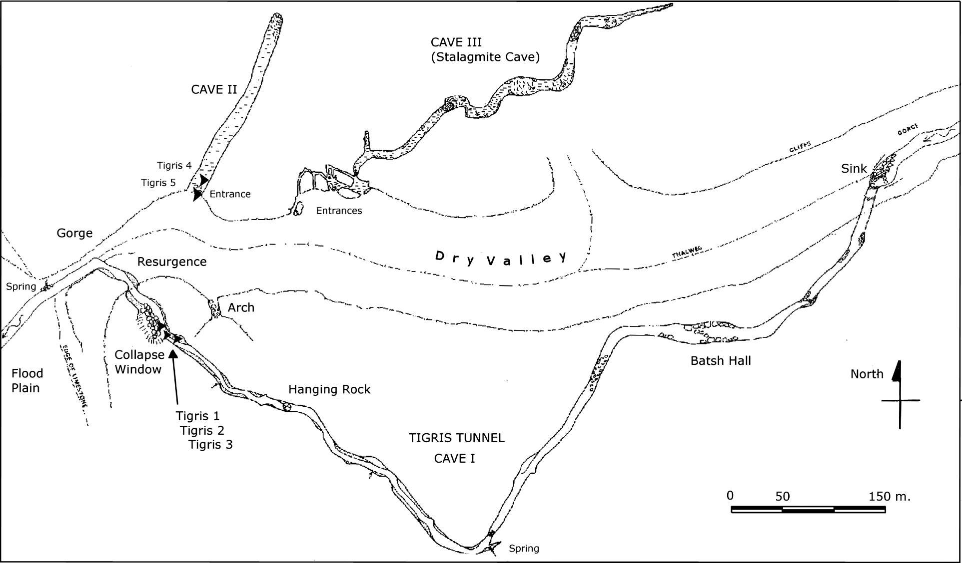
29 Plan of the Tigris Tunnel area and environs at Birkleyn Çay (after Waltham Reference Waltham1976). Courtesy of Tony Waltham.

30 Relief image of Tiglath-pileser I on the Lower Cave (Cave I) walls, with Tigris 1 cuneiform inscription to his left.

31 Tigris Tunnel-Birkleyn Çay, Upper Cave mouth with Shalmaneser III's relief and inscriptions.


