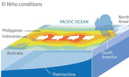
El Niño is a climate phenomenon that occurs when a vast pool of water in the eastern tropical Pacific Ocean becomes abnormally warm. Under normal conditions, the warm water and the rains it drives are in the western Pacific.
El Niño occurs every few years. Its most direct impacts are droughts in normally damp places in the eastern Pacific, such as parts of Indonesia and Australia, while normally drier places like the west coast of South America suffer floods.
But the changes affect the global atmospheric circulation and can weaken the Indian monsoon and bring rains to the western US.
It is not certain what tips the unstable Pacific Ocean-atmosphere system into El Niño, but a weakening of the normal trade winds that blow westwards is a key symptom. In 2014, the trigger may have been a big cluster of very strong thunderstorms over Indonesia in the early part of the year, according to Dr Nick Klingaman from the University of Reading in the UK.
An El Niño is officially declared if the temperature of the eastern tropical Pacific rises 0.5C above the long-term average. The extreme El Niño year of 1997-98 saw a rise of more than 3C.
El Niño is one extreme in a natural cycle, with the opposite extreme called La Niña. The effect of climate change on the cycle is not yet understood, though some scientists think El Niño will become more common.

Comments (…)
Sign in or create your Guardian account to join the discussion